|
|
|
AT A GLANCE
Objective
Advance ocean forecasts to predict eddy and front position accuracies to 10 km.
Approach
Prepare to exploit high resolution sea surface height observations by extending present ocean assimilation technology from the mesoscale domain to the submesoscale.
Impact
The ability to forecast frontal location will move forward by an order of magnitude. Present predictive skill is on the order of 100 km, and our plan is to improve to 10 km.
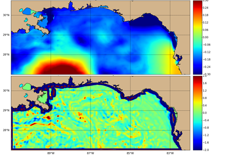
The
upper panel shows sea surface height from a 250 m resolution ocean model.
The large red feature in the lower left is a Loop Current Eddy that is 300 km
across. These are the typical mesoscale features forecast by present ocean
predictions. The lower panel shows the relative vorticity computed from the
sea surface height under a geostrophic assumption. The small scale (order 20
km) features are submesoscale eddies. The fact that they are ageostrophic is
implied by the relative vorticity being order 1.
Motivation
Operational ocean prediction in deep water has been restricted to mesoscale ranges based on computational capabilities that limited numerical model resolution in regional areas and observation systems that provide only mesoscale ranges. Recent 6.1 research has advanced dynamical understanding of submesoscale processes, continued expansion of computational capability has allowed representation of submesoscale dynamics across regional domains, and observation systems able to resolve the submesoscale will be available during the planned project timeline. In addition, the planned Surface Water / Ocean Topography (SWOT) satellite mission will provide sea surface height observations over the deep ocean at 1 km resolution across a 120 km swath, and this is expected to enable submesoscale prediction across the globe. We see the opportunity to advance the forecast capability of the Navy ocean environment to include the submesoscale domain. The Navy impact will be prediction of ocean environment features down to scales of 10 km.
Approach
Given a prior ocean forecast and a set of ocean observations, our approach will first correct the mesoscale eddy field using traditional methodology and then correct the submesoscale eddy field through the technology developed in this project. Dynamics are different within mesoscale and submesoscale eddies, and the dynamics of each control relations between sea surface height and underlying temperature, salinity and velocity. We break the technical approach into four components.
We will determine a practical dynamical relation between sea surface height and subsurface temperature, salinity and velocities. Mesoscale relations assume a dynamical balance between Coriolis force and horizontal pressure (a geostrophic balance) and assume that variations in subsurface density occur primarily between 200-400 m deep at the thermocline depth. These assumptions are not appropriate for the submesoscale. The submesoscale variability is primarily within the mixed layer (the upper 50-100m) and is not in a close approximation to geostrophic balance. A practical relation must both provide accurate dynamical balance between ocean variables and simultaneously minimize complexity to allow implementation in the systems in the second step of this approach. Submesoscale-resolving primitive equation model results based on full dynamical systems will be tested against existing analytic submesoscale relations to quantify accuracy of representation. Thus, from available theory we will determine a practical analytic expression balancing the trade-off between accurately representing submesoscale dynamics and minimizing complexity for efficient implementation.
We will generalize the solution process within the ocean analysis system that computes an optimal correction to a prior forecast given a set of observations. The present implementation is wired based on the mesoscale assumptions. The analysis system must be generalized to accept both the traditional mesoscale dynamical relation and our practical dynamical relation as operators that relate an observed variable to other variables. In this manner the analysis system maintains its applicability to the mesoscale problem using the historical geostrophic balance and thermocline relations, and at the same time the system extends its applicability to the submesoscale by integrating the dynamical relations determined in the first technical approach task. In addition, several solution methods are in operational use. The generalization must take into account methods in the present operational applications and planned operational methods. This will ensure results from the project will apply to systems over all forecast domains and will apply well into the future. With the generalization of the analysis process in hand, we are then at the point of sequentially applying the analysis to the mesoscale and submesoscale problems through the approach of the third task.
The
process of successively correcting first the mesoscale and then submesoscale
is a multiscale analysis. In this project, we will be changing both the
dynamical relations and the length and time scales within the sequential
analyses of the multiscale methodology. The first analysis will be conducted
for the mesoscale using historical relations and the second analysis will be
for the submesoscale using relations developed in this project. One
significant issue is the data provided to each analysis and the length and
time scales applied to each. There is an ambiguity relating a set of high
resolution observations to a mesoscale effect or a submesoscale effect. We
will address this ambiguity first through a simple separation of scales with
large scale features affecting mesoscale analysis and small scale features
affecting submesoscale. A refined separation will be constructed using
historical model experiments to relate scale variability at the thermocline
depth to the surface variability to separate the mesoscale. In addition, we
will test using the prior forecast to separate the mesoscale and submesoscale.
This analysis will guide the separation of features that have effect on the
deep thermocline as mesoscale eddy features, and 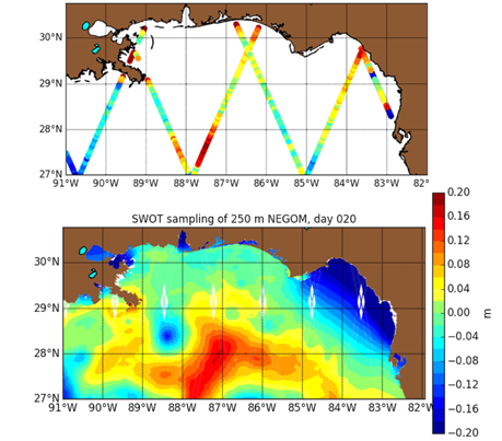
the remaining
features will affect the submesoscale.
The upper panel shows the coverage provided by the Jason nadir altimeter during a 10 day time period. The lower panel shows the expected coverage from SWOT. The upper panel are actual observations from Jason-2 that were assimilated into the 250 m resolution ocean prediction system. The lower panel is the sea surface height of the 250 m system sampled by the SWOT simulator.
We will conduct experiments to demonstrate submesoscale predictability and quantify the skill level reached. These require dense in situ observations. Prior collaborations have deployed 300 drifters in the small area of the northeastern Gulf of Mexico, and we are collaborating with experiments planned for 2016 that will deploy high density persistent observing systems such as 1000 drifters in the same area. The target for these experiments is observing surface divergence in fronts driven by submesoscale eddies. In addition, the aircraft version of SWOT (AirSWOT) developed by NASA will be conducting observation campaigns in several areas throughout the time period of this project, and we will leverage the data. These experiments will enable determination of submesoscale eddy predictive skill, though only in limited areas and during limited times. To expand these in situ tests, Observation System Simulation Experiments (OSSEs) are also required to represent the full SWOT data stream. We have conducted OSE experiments previously, and similar experiments will also provide insight to predictive skill relative to the planned SWOT system. We have been working closely with the SWOT engineering and science teams over the last few years. We have a SWOT simulator in which we can individually control the error sources, and this will provide the simulated observations from a numerical model experiment that serves as the nature run in the OSSEs.