|
Dynamic News |
|
|
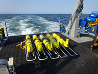
Smart Sea Gliders improve Ocean Observation and Ocean Prediction
Posted on January 30, 2020
|
Researchers frequently use gliders – slow-moving, long-endurance underwater vehicles – to collect data on ocean conditions such as temperature, depth, and salinity; in effect, observing the ocean’s weather.
“Predicting the ocean’s interior weather is challenging, yet it has important implications for all those who sail and operate on its waters,” said Jeffrey Book, Ph.D., an NRL oceanographer. “To help mitigate this problem,
the ocean observing community has been developing new techniques for autonomously measuring the ocean’s interior and reporting data back in real time.”
Because of the ocean’s vast volume, efficiently placing a relatively small number of gliders to capture observations of a dynamic environment can be tricky.
Recently, NRL researchers have been looking at ways to optimize glider placement, including using them in teams.
(Read more)
For more information contact author.
|
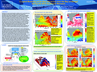
Coupled Modelling of Air-Sea Interaction over the Bay of Bengal during the 2018 Southwest Monsoon
Posted on January 30, 2020
|
Simulations of oceanic and atmospheric conditions and air-sea interaction over the Bengal are presented from a high resolution fully coupled from
atmosphere-ocean-waves models based on the Coupled Ocean Atmosphere Mesoscale Prediction System (COAMPS). The model is covering the Indian Ocean
north of 18S, with a horizontal resolution of about 3.5 km in the ocean, 9 km in the atmosphere and 10 km for the spectral surface wave model component.
Both the atmosphere model and ocean model have up to 60 vertical levels. A three-dimensional variationalmethod (3D-var) of data assimilation is applied
in the atmosphere and ocean models. The model runs on 622 cores on the Cray XC40 at the Navy DoD Supercomputing Resource Center.
(Read more)
For more information contact author.
|
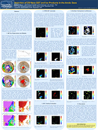
Overview of US Navy SST and Ice Products in the Arctic Seas
Posted on November 27, 2019
|
In prior years, scant attention has been focused on satellite retrieval of sea surface temperature (SST) in the Arctic,
as these areas have largely been covered by ice for most of the year. In recent years, thinning ice has exposed
increasingly large areas to the infrared satellite sensors, enabling such observations to potentially contribute
to global and regional assimilative forecast systems. We focus on VIIRS retrievals, examining these in terms of
repeat passes, orbital overlap between consecutive passes, and relative to scattered in situ observations. We also
examine the relationship between the SST retrievals and forecasts from the Global Ocean Forecast System (GOFS 3.1)
with coupled ocean-ice modeling using the Hybrid Coordinate Ocean Model (HYCOM) and the Community Ice Code (CICE).
(Read more)
For more information contact author.
|
System and method for correcting a model - derived vertical structure of ocean temperature
and ocean salinity based on sea surface height observations
Posted on October 2, 2019

|
System and method for correcting the vertical structure of
the ocean temperature and salinity can enable the use of sea
surface height ( SSH ) measurements to correct ocean fore
cast models . In the present embodiment , three relations that
can be precomputed are exploited : ( 1 ) the relation between
temperature and salinity throughout a water column , ( 2 ) the
relation between temperature / salinity and geopotential , and
( 3 ) the relation between geopotential and SSH .
(Read more)
For more information contact author.
|
System and method for isolating interial and non inertial velocities in the ocean
Posted on September 25, 2019

|
Patent a system to partition ocean velocities into time series of inertial and non-inertial components. The non-inertial components support more reliable
estimates of time-average transport by suppressing
the effects of superimposed inertial oscillations.
(Read more)
For more information contact author.
|
Evaluating the impact of satellite-derived ice thickness initialization in
predicting the September Arctic minimum sea ice extent
Posted on September 19, 2019

|
A series of twin experiments are performed to predict the September 2018 minimum ice extent using the fully coupled Navy Earth System Model (NESM),
which consists of the NAVy Global Environmental Model (NAVGEM), the HYbrid Coordinate Ocean Model, and the Community Ice CodE (CICE). In the control
run, ensemble forecasts are initialized from the operational US Navy Global Ocean Forecasting System (GOFS) 3.1 for the ocean
and sea ice using the Navy Coupled Ocean Data Assimilation (NCODA) system that assimilated SSMIS and AMSR2 sea ice concentration products.
(Read more)
For more information contact author.
|
Development of Two-Way Nesting in the Navy Coastal Ocean Model
Posted on September 9, 2019

|
We report on an ongoing effort to implement and test two-way embedding schemes in the Navy Coastal Ocean Model (NCOM), which can
run as a stand-alone ocean model, as well as a component within the Coupled Ocean/Atmospheric Mesoscale Prediction System (COAMPS).
We shall discuss the nesting strategy, the results of implementing various schemes and boundary conditions at the grid interface,
and issues associated with bathymetry inconsistency between the coarse and fine grids. Evaluations are based on idealized experiments
and real coastal simulations with tides and atmospheric surface forcing. Needs for improvements are addressed.
(Read more)
For more information contact author.
|
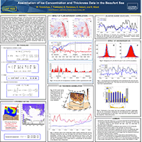
Assimilation of Ice Concentration and Thickness Data in the Beaufort Sea
Posted on August 28, 2019
|
Numerical experiments with a regional configuration of the CICE-HYCOM system in the Beaufort Sea assimilating SSMI ice concentration (IC)
and CryoSat ice thickness (IT) data acquired in September December of 2015 are presented. We explore sensitivity of the 24-hour IT/IC
forecast skill to the system updates, which include introduction of the IT assimilation capability, flow-dependent correlations, and
gaussianization of IC innovations. Experiments with IC data assimilation have shown that the flow-dependent correlations provide 5-7%
improvement of the forecast skill during the freezing period (10Sept–10Nov) while gaussianization contributes an additional improvement
of 3-4% in most of the cases.
(Read more)
For more information contact author.
|
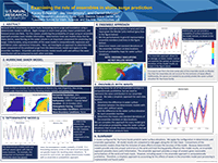
Examining the role of ensembles in storm surge prediction
Posted on August 5, 2019
|
Because of the uncertainty in storm track, forecasting storm surge and inundation using a deterministic model is difficult.
Slight changes in storm track greatly impact predictions, and forecast errors are likely. For this reason, predicting the
probability of surge using an ensemble approach provides more reliable information. Deterministic hind cast models show that
for many storms, wave forcing on the water column is an important component for predicting the surge.Unfortunately, using
ensembles of the wave model is computationally expensive and prohibitive under operational timescales.
(Read more)
For more information contact author.
|
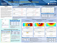
Influence of Shoals on SpatialVariability of Storm Surge
Posted on June 19, 2019
|
Idealized bathymetries were subjected to idealized cyclones in order to measure the storm surge response to a range of shoals,
under various storm conditions, for the purpose of informing the development of bathymetry thinning algorithms. Nine
bathymetries were considered, including eight shoals and a featureless reference domain. Six storm realizations
(two different sizes/intensities and three different landfall directions) were used as meteorological forcing.
(Read more)
For more information contact author.
|
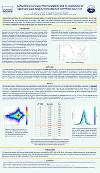
Surface boundary layer thermal stability and its relationship to significant wave height errors obtained from WAVEWATCH III
Posted on June 4, 2019
|
Significant wave height (Hs) calculated with the WAVEWATCH III® model deviates from the in-situ measurements from moored buoys. We hypothesize that this deviation would be smaller if the model used
a well-calibrated method to account for stability variations within the surface boundary layer (SBL). This research determines a relationship between such errors and the SBL thermal stability.
It can be exploited to create an empirical correction to wind speed, an “effective wind speed”.
(Read more)
For more information contact author.
|
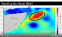
SCIENTISTS TRACK GIANT OCEAN VORTEX FROM SPACE
Posted on May 23, 2019
|
Researchers have found a new way to use satellites to monitor the Great Whirl, a massive whirlpool the size of Colorado that forms each year off the coast of East Africa, they report in a new study.
Using 23 years of satellite data, the new findings show the Great Whirl is larger and longer-lived than scientists previously thought. At its peak, the giant whirlpool is, on average, 275,000 square
kilometers (106,000 square miles) in area and persists for about 200 days out of the year.
(Read more)
For more information contact author.
|
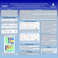
Parameterization of the Inverse Error Covariances for SWOT Altimetry
Posted on May 9, 2019
|
High-resolution (swath) altimeter missions scheduled to monitor the ocean surface in the near future have observation error covariances (OECs) with slowly decaying off-diagonal elements.
This property presents a challenge for the majority of the data assimilation (DA) algorithms which were designed under the assumption of the diagonal OECs being easily inverted. We present a
method of approximating the inverse of a dense OEC by a sparse matrix represented by the polynomial of spatially inhomogeneous differential operators, whose coefficients are optimized to
fit the target OEC by minimizing a quadratic cost function.
(Read more)
For more information contact author.
|
Regional Ocean Data Assimilation using the Local Ensemble Transform Kalman Filter (LETKF) with the Navy Coastal Ocean Model
Posted on April 22, 2019
|
A globally relocatable regional ocean nowcast/forecast system developed at the Naval Research Laboratory is modified to use the Local Ensemble Transform Kalman Filter (LETKF)
for data assimilation. We present initial results using the LETKF with the NCOM/NCODA forecast system in a regional model in comparison with a perturbed-observation ensemble.
(Read more)
For more information contact author.
|
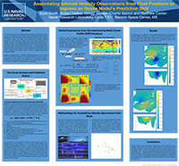
Assimilating Inferred Velocity Observations from Float Positions to Improve an Ocean Model’s Prediction Skill
Posted on March 13, 2019
|
The Navy Coupled Ocean 3D Variational Data Assimilation (NCODA-VAR) system is one of the primary tools that the Navy uses operationally to ingest, process, quality and control,
and assimilate ocean observations in near-real time in order to regularly update and improve the forecast skill of several different operational ocean prediction systems.
One of the current deficiencies of NCODA, however, is its inability to properly assimilate velocity observations. It lacks the mechanism to correlate velocities with temperature
and salinity, which the analysis needs in order to be dynamically stable.
(Read more)
For more information contact author.
|
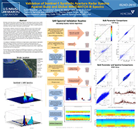
Validation of Sentinel-1 Synthetic Aperture Radar Spectra Against Buoy and Global WAVEWATCH III Spectra
Posted on March 6, 2019
|
We developed a validation procedure for Sentinel-1 SAR wave spectra that includes quality control measures. The current routine for validating SAR wave spectra against buoy wave
spectra is shown (center panel). Pairs of SAR and buoy wave spectra are spatially and temporally colocated (within 1°and 0.5 hours, respectively). Bulk parameters (e.g., significant
wave height, various wave periods, measures of spectral bandwidth, and the fourth spectral moment) calculated from the SAR spectra are compared graphically and statistically to those
calculated from the buoy spectra.
(Read more)
For more information contact author.
|
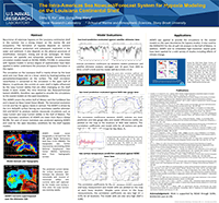
The Intra-Americas Sea Nowcast/Forecast System for Hypoxia Modeling on the Louisiana Continental Shelf
Posted on February 1, 2019
|
Recurrence of extensive hypoxia on the Louisiana continental shelf in the summer has a strong impact on the marine life and ecosystems. The formation of
hypoxia depends on nutrient enhanced primary production and subsequent respiration in the water and sediment. It also depends on the physical processes
of stratification, transport, mixing and air-sea exchanges. All these processes are spatially and temporally variable. Several coastal circulation models
based on NCOM, ROMS, FVCOM, in conjunction with hypoxia models in various degree of sophistication have been applied to better understand the processes of
hypoxia formation in the region.
(Read more)
For more information contact author.
|
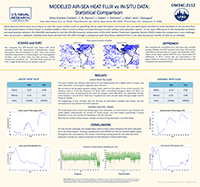
Modeled Air-Sea Heat Flux vs IN-SITU DATA: Statistical Comparison
Posted on January 24, 2019
|
Many physical phenomena occurring at or near the ocean surface (such as upwelling, dense water formation, hurricanes, etc.) are particularly
sensitive to small variations in air-sea heat flux. The parameterization of these fluxes in coupled models is then crucial to obtain accurate
forecasts in both surface and subsurface events. In our case, differences in the horizontal resolution and pixel position between the NAVGEM
(atmospheric) and the HYCOM (oceanic) components of the Earth System Prediction Capability System (ESPC) makes this comparison a rare challenge.
Here we present a validation of global heat fluxes derived from the ESPC through a comparison with heat fluxes obtained from in-situ data during
two months of 2015 as an example.
(Read more)
For more information contact author.
|
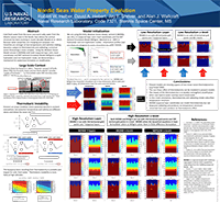
Nordic Seas Water Property Evolution
Posted on January 3, 2019
|
Cold fresh water from the Arctic and warm salty water from the Atlantic oceans meet in the Nordic Seas where the vertical structure has been evolving in
recent decades. Because water properties are changing and seawater non-linearities are stronger at low temperatures and salinities
making dynamics subject to thermobaricity and cabbeling, numerical ocean forecasting is more complex. Using the Modular Ocean Model version 6 (MOM6) with
both isopycnal layer and z-level coordinates and MIT General Circulation Model (MITgcm) in both hydrostatic and non-hydrostatic mode, we demonstrate a
mechanism for water mass formation or modification.
(Read more)
For more information contact author.
|
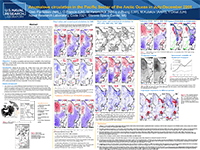
Anomalous circulation in the Pacific Sector of the Arctic Ocean in July-December 2008
Posted on December 27, 2018
|
Variability of the mean summer-fall ocean state in the Pacific Sector of the Arctic Ocean (PSAO) is studied using a dynamically constrained synthesis
(4Dvar) of historical in situ observations collected during 1972 to 2008. It is shown that the PSAO circulation during July-December of 2008 was characterized by a pronounced negative
Sea Surface Height (SSH) anomaly along theEurasian shelf break, which caused a significant decline of the transport in the Atlantic Water (AW) inflow
region into the PSAO and increased the sea level difference between the Bering and Chukchi Seas.
(Read more)
For more information contact author.
|
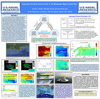
Exploring Fine-Scale Ocean Fronts in the Mississippi Bight Coastal Zone
Posted on December 17, 2018
|
High-resolution modeling of the Mississippi Bight has allowed for further research and examination of the development of mesoscale frontal
boundaries in the northern Gulf of Mexico. Such high-resolution modeling is necessary to diagnose the development of Lagrangian Coherent
Structures (LCS) which can alter physical, acoustical, and biological processes over short periods of time. The field work to take place
in March and April 2018 will further enhance our knowledge of these frontal boundary structures, and lead to better understanding of these
structures in the coastal zone.
(Read more)
For more information contact author.
|
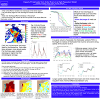
Impact of Freshwater from Arctic Rivers in a High-Resolution Model
Posted on December 13, 2018
|
A high-resolution model is run for three years in the Arctic to observe the impact of changing the freshwater input from river discharge.
The model is run with five different river scenarios. The “base case” uses climatological rivers with monthly resolution. A second case
uses daily river discharge values for six major rivers, introducing both shorter-term and interannual variability. In the third case, the
river discharge values are increased by a factor of five, while in the fourth case, the rivers are turned off. These cases allow us to
observe what part of the freshwater variability is fully independent of the rivers, and how both local and large-scale freshwater content
is affected by variations in river discharge.
(Read more)
For more information contact author.
|
Improving Arctic sea ice edge forecasts by assimilating
high resolution VIIRS sea ice concentration data into the U.S. Navy’s ice forecast systems
Posted on November 13, 2018

|
This study demonstrates the improvement in the ice edge location for both the Arctic and Antarctic regional seas by
assimilating the high resolution VIIRS ice concentration products. This new data source is scheduled to be
implemented into the pre-operational GOFS 3.1 job stream in Spring 2018.
(Read more)
For more information contact author.
|
Automated system and method for vertical gradient correction
Posted on October 23, 2018

|
System and method for maintaining the observed vertical structure of ocean temperature and salinity in data assimilation
systems that otherwise would produce overly smoothed ocean vertical structure. The present embodiment
uses a multi-layer least squares minimization technique in which the ocean is split into layers with fundamentally
different vertical gradients, and the dynamic ocean layers are constrained by the observed vertical gradients of the layer itself.
(Read more)
For more information contact author.
|
System and method for correcting a model-derived vertical structure of ocean temperature and ocean salinity based on velocity observations
Posted on October 23, 2018

|
System and method for correcting the vertical structure of the ocean temperature and salinity based on velocity observations.
Three relations that can be precomputed are exploited: (1) the relation between temperature and salinity
throughout a water column, (2) the relation between temperature/salinity and geopotential, and (3) the relation
between geopotential and velocity. The relations are stored in a form that allows efficient application through a crosscorrelation matrix.
(Read more)
For more information contact author.
|
| |