|
|
Global Ocean Forecast System |
||
What is it?
An operational global ocean/ice nowcasting and forecasting system that runs daily at the Naval Oceanographic Office.
How does it work?
The system assimilates availiable ocean surface and subsurface observations to constrain the ocean interior at the initial time.
The numerical ocean model then acts as a dynamical interpolator to accurately forecast the initial state forward in time.
What will it accomplish?
The system provides the fleet with a description of the 3-dimensional ocean structure, the location of mesoscale features such as eddies and ocean
fronts, ice parameters and environmental conditions with an accuracy superior to climatology and/or persistence, i.e. a forecast of no change.

Sea surface height (cm) on 31 August 2016 from the Global
Ocean Forecast System (GOFS) 3.1.The gray areas in the polar latitudes
represent sea ice.
In general, ocean currents flow parallel to the isolines
with faster velocities found where the height gradients are tighter. Circular
height contours represent mesoscale eddies.
The next generation Global Ocean Forecast System (GOFS 3.1) is a Navy ocean/ice nowcasting and forecasting capability based on the HYbrid Coordinate Ocean Model (HYCOM), two-way coupled to the Community Ice CodE (CICE) and using the Navy Coupled Ocean Data Assimilation (NCODA). It runs daily at the Navy DoD Supercomputing Resource Center creating a nowcast through a 7-day forecast. The system 1) depicts the location of mesoscale features such as oceanic eddies and fronts, and provides 2) accurate 3-dimensional ocean temperature, salinity, and current structure, 3) boundary conditions for regional and nested coastal models, 4) acoustical proxy measures (mixed layer depth, sonic layer depth, below layer gradient and deep sound channel axis), and 5) ice concentration, thickness and drift.
The existing global prediction capability (GOFS 3.0) was declared operational in September 2013 and is based upon global HYCOM with a horizontal resolution of 1/12.5° (~9 km at the equator, ~7 km at mid-latitudes) and 32 hybrid vertical layers. GOFS 3.0 includes a relatively simple embedded thermodynamic ice model. NCODA assimilates surface observations from satellites, such as altimeter sea surface height (SSH) anomalies and sea surface temperature (SST), plus in situ SST observations from ships and buoys as well as temperature and salinity profile data from expendable bathythermographs, conductivity-temperature-depth sensors, gliders and Argo floats. The ocean model uses atmospheric forcing from the operational Navy Global Environmental Model that is run daily at Fleet Numerical Meteorology and Oceanography Center.
Mesoscale eddies are ubiquitous across the global ocean and have impacts on phenomena ranging from ocean acoustic propagation to zooplankton production. Thus, it is essential that a prediction system accurately represent these features of the oceanic "weather" This is achieved mainly through assimilation of satellite altimeter data, but the ocean model itself must also be a good dynamical interpolator of this input data stream. Eddies must be properly maintained and have accurate propagation speeds when they become unobserved between altimeter tracks. For the world ocean, GOFS has been shown to have skill predicting SSH anomalies out to 30+ days, although this lessens to about 10 days for the Gulf Stream and 16 days for the Kuroshio (which are the highly non-linear western boundary currents of the Atlantic and Pacific Oceans, respectively).
 |
 |
||
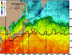
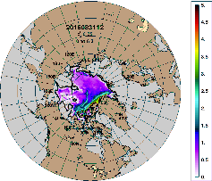
| Sea surface temperature (°C) for the Kuroshio Expension region from GOFS 3.1 for 31 August 2016. The black line is an independent frontal analysis of satellite SST data performed by the Naval Oceanographic Office. | Sea ice thickness (m) for the Arctic from GOFS 3.1 for 31 August 2016. The black line is independent ice edge analysis from the National Ice Center. |
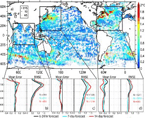
Accurate forecasts of the subsurface temperature, salinity, and velocity structure are a first order requirement for Navy ocean prediction systems. The vertical distributions of temperature and, to a lesser extent salinity, determine the sound speed properties. The near-surface stratification, surface mixed layer, and thermocline gradient also play important roles in the sound propagation. Therefore, the predictability of ocean temperature and salinity is vital to accurate simulation of the underwater acoustical environment ‒ a key Navy concern. See the figure directly below.
 |
Temperature (°C) vs. depth error analysis against unassimilated profiles during a data assimilative hindcast spanning 2012. (a) RMSE in 2° bins averaged over the top 500 m at 00Z. Approximately 100,000 profiles went into the analyisisand the number of profiles in each bin is denoted by the legend in Asia. (b-d) Mean error and RMSE as a function of depth and forecast length for the three regions outlined in (a). Thcurves are for the 6-24 hour short-term forecast,the cyan curves for the seven-day forecast, e black and the red curves for the 14-day forecast. The average number of observations in each analysis is denoted by N = XXX. Model-data differences greater than three standard deviations are excluded from the analysis. NOGAPS atmspheric forcing was used in the hindcast and forecasts for this analysis |
Future GOFS developments
GOFS 3.1 is scheduled to replace GOFS 3.0 in 2017 after it has undergone validation and verification testing at both the Naval Research Laboratory and the Naval Oceanographic Office. It will include (1) an increase in HYCOM's vertical resolution from 32 to 41 layers, with the nine new layers added near the surface to improve upper ocean prediction, (2) an improved method for projecting altimeter-based sea surface anomaly information into the ocean interior with Improved Synthetic Ocean Profiles, and (3) two-way coupling between HYCOM and CICE, which includes improved ice physics and rheology.
By 2018, GOFS 3.5 will include a horizontal resolution increase to 1/25° (~4.5 km at the equator, ~3.5 km at mid-latitudes) and the addition of tidal forcing. This system will provide boundary conditions for even higher resolution coastal models and serve as the backbone of a globally relocatable ocean nowcast/forecast capability that will address the need for littoral or deep water support anywhere in the world, without the need for most intermediate regional models.
This work sponsored by ONR and SPAWAR