EASNFS
Experimental Real-Time
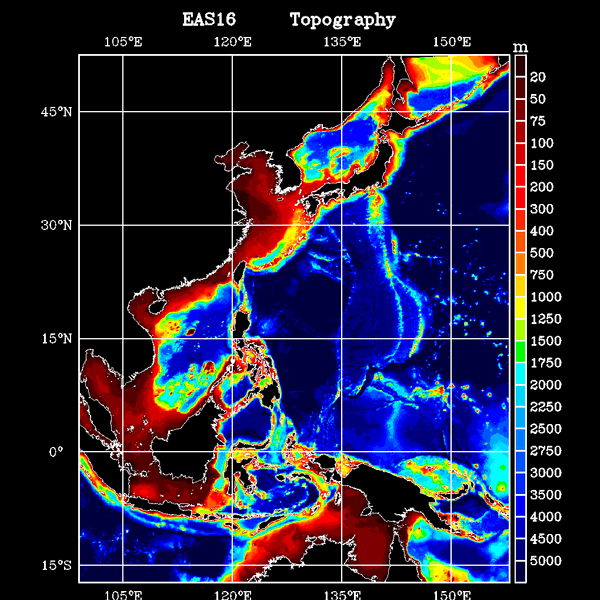
East Asian Seas Ocean Nowcast/Forecast System
EASNFS
is an experimental real-time Ocean Nowcast/Forecast System for the East Asian
Seas. The area of coverage is from 17.3S to 52.2N and from 99.2E to 158.2E.
It includes all the Asian Marginal Seas - South China Sea, East China Sea,
Yellow Sea and Sea of Japan. The system produces nowcast the sea level
variation, 3D ocean current, temperature and salinity fields daily.
|
EASNFS consists an ~1/16 degree, 41-level sigma-z data-assimilating ocean model based on NCOM (Navy Coastal Ocean Model). The horizontal resolution ranges from 9.8 km at Equator and ~6.5 km at northern boundary.
The model topography is from 2-min NRL DBDB2
bathymetry data base and improved with available high resolution bathymetry and sounding data.
For daily nowcast the model is restarted from previous nowcast at -72 hr.
Once model is restarted it continuously assimilates the synthetic temperature/salinity profiles generated by a data analysis model called MODAS to produce nowcast.
Real-time data come from satellite altimeter (GFO, Jason-1, ERS-2, EnviSat and TOPEX) sea surface height anomaly and AVHRR sea surface temperature.
Three hourly surface heat fluxes, solar radiation, wind stresses and sea level air pressure from NOGAPS/FNMOC are applied for surface forcing.
Once the nowcast are produced they are distributed through the internet via the updated web pages.
|
The open boundary conditions including sea surface elevation, transport, temperature, salinity and currents are provided by the NRL Global NCOM which is operated daily.
An one way coupling scheme is used to ingest those boundary conditions into the EASNFS model. There are 142 rivers or fresh water runoff points with monthly discharges in the EASNFS.
|
EASNFS is a fully automated end-to-end ocean prediction system operated at NRL Oceanography Division with founding provided by ONR as a part of NLIWI and ITOP.
| |
|---|
Related Applications of EASNFS including embbeded high resolution grids
|
Ko, D.S., S.-Y. Chao, C.-C. Wu, I-I Lin, and S. Jan (2016),
Impacts of Typhoon Fanapi (2010) on Seas around Taiwan, Terr.
| Atmos. Ocean. Sci., 27, 261-280, doi:10.3319/TAO.2015.10.28.01(Oc).
Wu, C.-C., W.-T. Tu, I.-F. Pun, I-I. Lin, and M.S. Peng (2016),
Tropical cyclone-ocean interaction in Typhoon Megi (2010). A
| synergy study based on ITOP observations and atmosphere-ocean coupled model simulations, J. Geophys. Res. Atmos., 121, 153-167, doi:10.1002/2015JD024198.
Pickering, A., M. Alford, J. Nash, L. Rainville, M. Buijsman,
D.S. Ko, and B. Lim (2015), Structure and variability of internal
| tides in Luzon Strait, J. Phys. Oceanogr., 45, 1574-1594, doi:10.1175/JPO-D-14-0250.1.
Warn-Varnas, A., D.S. Ko, and A. Gangopadhyay (2015), Signatures
of tidal interference patterns in South China Sea, J.
| Oceanogr., 71, 251-262, doi:10.1007/s10872-015-0282-8.
Ko, D.S., S.-Y. Chao, C.-C. Wu, and I-I Lin (2014), Impacts of
Typhoon Megi (2010) on the South China Sea, J. Geophys. Res.
| Oceans, 119, 4474-4489, doi:10.1002/2013JC009785.
Chen, Y.-J., D.S. Ko, and P.-T. Shaw (2013), The generation and
propagation of internal solitary waves in the South China Sea,
| J. Geophys. Res. Oceans, 118, 6578-6589, doi:10.1002/2013JC009319.
Lee, I.-H., D.S. Ko, Y.-H. Wang, L. Centurioni, and D.-P. Wang (2013),
The mesoscale eddies and Kuroshio transport in the
| western North Pacific east of Taiwan from 8-year (2003-2010) model reanalysis, Ocean Dynamics, 63, 1027-1040, doi:10.1007/s10236-013-0643-z.
Ma, B.B., R.-C. Lien, and D.S. Ko (2013), The variability of internal
tide in the northern South China Sea, J. Oceanogr., 69,
| 619-630, doi:10.1007/s10872-013-0198-0.
Lin, I.-I., C. Hu, Y.-H. Li, T.-Y. Ho, T. Fischer, G.T.F. Wong,
J. Wu, C.-W. Huang, D.A. Chu, D.S. Ko, and J.-P. Chen (2011),
| Fertilisation potential of volcanic dust in the low nutrient low chlorophyll western North Pacific Subtropical Gyre - satellite evidence and laboratory study, Global Biogeochem. Cycles, doi:10.1029/2009GB003758.
Simmons, H., M.-H. Chang, Y.-T. Chang, S.-Y. Chao, O. Fringer,
C.R. Jackson, and D.S. Ko (2011), Modeling and prediction of
| internal waves in the South China Sea, Oceanography, 24, 88-99, http://dx.doi.org/10.5670/oceanog.2011.97.
Chang, Y.-T., T.Y. Tang, S.-Y. Chao, M.-H. Chang, D.S. Ko, Y.J. Yang,
W.-D. Liang, and M.J. McPhaden (2010), Mooring
| observations and numerical modeling of thermal structures in the South China Sea, J. Geophys. Res. Oceans, doi:10.1029/2010JC006293.
Qian H., P.-T. Shaw, and D.S. Ko (2010), Generation of internal waves by
barotropic tidal flow over a steep ridge, Deep-Sea
| Res. I, 57, 1521-1531, doi:10.1016/j.dsr.2010.09.001.
Ko, D.S., P. Martin, S.-Y. Chao, P.-T. Shaw, and R.C. Lien (2009),
Internal Waves at South China Sea, NRL Review, 2008,
| 183-186.
Ko, D.S., S.-Y. Chao, P. Huang, and S.F. Lin (2009), Anomalous upwelling
in Nan Wan: July 2008, Terr. Atmos. Ocean. Sci., 20,
| 839-852, doi:10.3319/TAO.2008.11.25.01(Oc).
Chao, S.-Y., D.S. Ko, R.C. Lien, and P.T. Shaw (2007), Assessing the
west ridge of Luzon Strait as an internal wave mediator, J.
| Oceanogr., 63, 897-911, doi:10.1007/s10872-007-0076-8.
Keen, T.R., D.S. Ko, R.L. Slingerl, and S. Riedlinger (2006), Potential
transport pathways of terrigenous material in the Gulf of
| Papua, Geophys. Res. Lett., 33, L04608, doi:10.1029/2005GL025416.
Teague, W.J., D.S. Ko, G.A. Jacobs, H.T. Perkins, J.W. Book, S.R. Smith,
K.-I. Chang, M.-S. Suk, K. Kim, S.J. Lyu, and T.Y.
| Tang (2006), Currents across the Korea/Tsushima strait: review of LINKS observations, Oceanography, 19, 53-65. |
|---|
Back to EASNFS Home